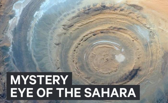
Known also as the Richat Structure or the Guelb er Richat, the Blue Eye of the Sahara is a geological formation in the Sahara Desert that somewhat resembles an enormous bullseye in shape. In Mauritania, there is a formation that extends across a region of the desert that stretches across 40 kilometers wide.
Table of Contents
Key Takeaways: The Eye of the Sahara
- The Eye of the Sahara, also known as the Richat Structure or Eye of the Sahara, is a geologic dome containing rocks that predate the appearance of life on earth by millions of years.
- Its shape resembles that of a blue bullseye and is located in the Western Sahara region. As a visual landmark, it has been used by astronauts as a visual landmark from space, and is visible from space.
- It is believed that the formation of the Eye began around the time when the supercontinent Pangaea began to separate from one another.
For centuries, only a few local nomadic tribes were aware of the existence of this formation. The first time it was photographed was by the Gemini astronauts, who used the landmark as a marker to follow the progress of their landing sequences during the 1960s. The Landsat satellite captured additional images and provided information about the size, height, and extent of the formation as a result of those images.
It was initially believed that Eye of the Sahara was an impact crater, created as a result of an object from space slamming into the surface of the Sahara Desert. As a result of lengthy studies of rocks found inside the structure, it is evident that its origins are entirely earth-based in origin.
A Unique Geological Wonder
In recent years, geologists have concluded that the Eye of the Sahara is a geologic dome. A large part of the formation contains rocks that are at least 100 million years old. Some of these rocks date back well before life appeared on this planet. In addition to igneous deposits (volcanic), these rocks also contain sedimentary layers that form as the wind pushes dust layers and water deposits sand and mud on the surface of these rocks. There are several types of igneous rock that can be found today in the area of the eye, including kimberlite, carbonatites, black basalts (similar to the black basalts found on the Big Island of Hawaii) and rhyolites, among others.
The entire landscape surrounding the Eye was lifted millions of years ago by volcanic activity deep beneath the surface of the Earth. It is important to note that these regions were not deserts as they are today. There is a good chance that the climate was much more temperate and there was plenty of flowing water. During the temperate period, layers of layered sandstone were deposited on the bottoms of lakes and rivers by blowing winds as well as on the bottoms of rivers and lakes. A subsurface volcanic flow eventually pushed up layers of sandstone and other rocks which were overlying the volcanic flow. As the volcanism died down, wind and water erosion began to eat away at the domed layers of rock as they eroded away. There was a period of time when the region began to settle down and collapse in on itself, creating the roughly circular shape of the “eye”.
Traces of Pangaea
Researchers have been able to learn more about the origins of the Eye of the Sahara by studying the ancient rocks located within it. When the supercontinent Pangaea began to break apart, the earliest formation of the Eye began to take place. As Pangaea broke apart, the waters of the Atlantic Ocean began to flow into the region as a result.
As Pangaea slowly began to separate as it was slowly pulled apart, magma from deep within the Earth’s mantle began to push up through the crust, resulting in the formation of a rocky dome surrounded by layers of sandstone forming a circle-shaped structure. After erosion took its toll on the igneous rocks and sandstones, and as the dome subsided, circular ridges were left behind, giving the Richat Structure its sunken circular form as the igneous rocks eroded away. In today’s world, the eye is somewhat sunken below the level of the landscape around it.
Seeing the Eye
During the formation of the Eye, the Western Sahara no longer had the temperate conditions that existed at that time. Nevertheless, it is possible to visit the dry, sand desert that the Eye of the Sahara calls home-but it is not a luxury trip. The first step for travelers is to obtain a Mauritanian visa and to find a local sponsor who can sponsor them while they are here.
Tourists are advised to make local travel arrangements once they have been admitted to the facility. A number of entrepreneurs offer airplane rides or hot air balloon rides over the Eye to provide visitors with a bird’s-eye view of the site. The Eye is located near the town of Oudane, which is a short car ride away from the structure, as well as the Eye itself. There is even a hotel within the structure itself.
The Future of the Eye
Both tourists and geologists flock to the Eye of the Sahara to study the unique geological feature in person, as both are attracted by the Eye’s unique geological features. In spite of this, since the Eye is situated in a sparsely inhabited region of the desert with very little water and rainfall, it is not under much threat from humans due to its remote location.
This leaves the Eye open to the vagaries of nature, which are beyond our control. The ongoing effects of erosion pose a threat to the landscape, just as they do in other parts of the world as well. Due to climate change, there may well be more dunes brought to the region by desert winds, especially since there is increasing desertification in the area as a result of climate change. It is quite possible that, in the distant future, the Eye of the Sahara will be covered in sand and dust as a result of the onset of global warming. As a result, future travelers may find only a windswept desert burying one of the most striking geological formations on the planet under a windswept desert.
What Is the Eye of the Sahara?
Known also as the Richat Structure or the Guelb er Richat, the Blue Eye of the Sahara is a geological formation in the Sahara Desert that somewhat resembles an enormous bullseye in shape. In Mauritania, there is a formation that extends across a region of the desert that stretches across 40 kilometers wide.
Key Takeaways: The Eye of the Sahara
- The Eye of the Sahara, also known as the Richat Structure or Eye of the Sahara, is a geologic dome containing rocks that predate the appearance of life on earth by millions of years.
- Its shape resembles that of a blue bullseye and is located in the Western Sahara region. As a visual landmark, it has been used by astronauts as a visual landmark from space, and is visible from space.
- It is believed that the formation of the Eye began around the time when the supercontinent Pangaea began to separate from one another.
For centuries, only a few local nomadic tribes were aware of the existence of this formation. The first time it was photographed was by the Gemini astronauts, who used the landmark as a marker to follow the progress of their landing sequences during the 1960s. The Landsat satellite captured additional images and provided information about the size, height, and extent of the formation as a result of those images.
It was initially believed that Eye of the Sahara was an impact crater, created as a result of an object from space slamming into the surface of the Sahara Desert. As a result of lengthy studies of rocks found inside the structure, it is evident that its origins are entirely earth-based in origin.
A Unique Geological Wonder
In recent years, geologists have concluded that the Eye of the Sahara is a geologic dome. A large part of the formation contains rocks that are at least 100 million years old. Some of these rocks date back well before life appeared on this planet. In addition to igneous deposits (volcanic), these rocks also contain sedimentary layers that form as the wind pushes dust layers and water deposits sand and mud on the surface of these rocks. There are several types of igneous rock that can be found today in the area of the eye, including kimberlite, carbonatites, black basalts (similar to the black basalts found on the Big Island of Hawaii) and rhyolites, among others.
The entire landscape surrounding the Eye was lifted millions of years ago by volcanic activity deep beneath the surface of the Earth. It is important to note that these regions were not deserts as they are today. There is a good chance that the climate was much more temperate and there was plenty of flowing water. During the temperate period, layers of layered sandstone were deposited on the bottoms of lakes and rivers by blowing winds as well as on the bottoms of rivers and lakes. A subsurface volcanic flow eventually pushed up layers of sandstone and other rocks which were overlying the volcanic flow. As the volcanism died down, wind and water erosion began to eat away at the domed layers of rock as they eroded away. There was a period of time when the region began to settle down and collapse in on itself, creating the roughly circular shape of the “eye”.
Traces of Pangaea
Researchers have been able to learn more about the origins of the Eye of the Sahara by studying the ancient rocks located within it. When the supercontinent Pangaea began to break apart, the earliest formation of the Eye began to take place. As Pangaea broke apart, the waters of the Atlantic Ocean began to flow into the region as a result.
As Pangaea slowly began to separate as it was slowly pulled apart, magma from deep within the Earth’s mantle began to push up through the crust, resulting in the formation of a rocky dome surrounded by layers of sandstone forming a circle-shaped structure. After erosion took its toll on the igneous rocks and sandstones, and as the dome subsided, circular ridges were left behind, giving the Richat Structure its sunken circular form as the igneous rocks eroded away. In today’s world, the eye is somewhat sunken below the level of the landscape around it.
Seeing the Eye
During the formation of the Eye, the Western Sahara no longer had the temperate conditions that existed at that time. Nevertheless, it is possible to visit the dry, sand desert that the Eye of the Sahara calls home-but it is not a luxury trip. The first step for travelers is to obtain a Mauritanian visa and to find a local sponsor who can sponsor them while they are here.
Tourists are advised to make local travel arrangements once they have been admitted to the facility. A number of entrepreneurs offer airplane rides or hot air balloon rides over the Eye to provide visitors with a bird’s-eye view of the site. The Eye is located near the town of Oudane, which is a short car ride away from the structure, as well as the Eye itself. There is even a hotel within the structure itself.
The Future of the Eye
Both tourists and geologists flock to the Eye of the Sahara to study the unique geological feature in person, as both are attracted by the Eye’s unique geological features. In spite of this, since the Eye is situated in a sparsely inhabited region of the desert with very little water and rainfall, it is not under much threat from humans due to its remote location.
This leaves the Eye open to the vagaries of nature, which are beyond our control. The ongoing effects of erosion pose a threat to the landscape, just as they do in other parts of the world as well. Due to climate change, there may well be more dunes brought to the region by desert winds, especially since there is increasing desertification in the area as a result of climate change. It is quite possible that, in the distant future, the Eye of the Sahara will be covered in sand and dust as a result of the onset of global warming. As a result, future travelers may find only a windswept desert burying one of the most striking geological formations on the planet under a windswept desert.